Simulating spatiotemporal changes in land-use functions in Guyuan, China, using an agent-based model dependent on multi-level stakeholder participation
Keywords
Agent-based modeling · China · Guyuan · Land-use functions · Stakeholders
Highlights
- An agent-based model was developed to simulate land-use functions (LUFs).
- Multi-level stakeholders were involved in the assessment procedure and are reflected in the model.
- Agricultural land abandonment is a potentially critical land-use issue, and land reform and associative measures are urgently needed.
1. Introduction
Over the past five to six decades, ecosystems have witnessed rapid and extensive changes having been impacted by the rapidly growing demand for food, health and natural resources (Millennium Ecosystem Assessment, 2005; Kappas, Gross & Kelleher 2012). By 2011, such pressure caused a 61% increase in global land degradation, threatening sustainable land management at local, regional and global scales (Liniger, Mekdaschi, Moll, & Zander, 2017; Orr et al., 2017; FAO, 2011). The Sustainable Development Goals (SDGs) initiative published by the United Nations (UN) in 2016 highlights in 7 of its 17 goals the importance of sustainable land use (United Nations, 2017). Seeking a more integrative understanding of coupled human-environment systems and cooperation between the scientific and decision-making communities to tackle critical problems associated with such systems is currently a key issue for policy and scientific communities, especially in developing countries.
Land-use functions (LUFs) refer to the goods and services provided by different land uses, and they summarize the most regionally relevant economic, environmental and societal issues (Pérez-Soba et al., 2008; Zhen et al., 2009). The LUF framework was originally developed to stress the need to evaluate land-use change impacts on regional sustainability in a manner that reflects economic, social and environmental dimensions (Pérez-Soba et al., 2008). It has been widely used to assess regional sustainable development under both a developed and developing context around the world (Wiggering, Müller, Werner, & Helming, 2003; König, 2013). For instance, König et al. (2010) conducted a policy-focused sustainability impact assessment induced by land-use changes in Yogyakarta City, Indonesia, by developing a set of nine key LUFs and associated indicators, including three social, three economic and three environmental sustainability criteria (König et al., 2010). Xie et al. (2010) identified 16 sub-functions within economic, social and environmental dimensions to assess the multifunctionalities of land use, and they found that land conversion policies significantly affect land-use patterns in China, reflected in a decrease in arable land, grassland and built-up areas and an increase in forestland area. The concept nowadays has been extended to support solution-oriented research and encourage policy development (Peng, Liu, Liu, Hu, & Wang, 2015; Wei, 2010).
However, regional policymakers often lack access to theoretical or rational impact assessment results that land-use policies have on local development, and this appears to be more critical in remote agricultural areas. Guyuan, in the Ningxia Hui Autonomous Region, China, is a remote and less-developed region comprised of complex landforms and fragile soil conditions. The Government of China has established a nationwide sloping land conversion program in this region since 2000, which has effectively helped to conserve local soil erosion, but it appears to have potentially caused agricultural land abandonment and food safety problems (Xue & Zhen, 2018). Land-use scenario assessments are needed for local policymakers to promote and adjust local land management methods and pursue land sustainability measures. Furthermore, regional sustainable land-use assessments have mainly focused on non-objective regional evaluations, but research on spatial visualization assessment results is limited. However, the visualization of regional sustainable statuses can help policymakers to obtain a more specific and direct understanding while being beneficial in recognizing land-use problems in which to take appropriate land management measures.
Land change modelling is used to explain and forecast both land and landscape conditions, providing spatial results of land-use changes. Such models play a key role in decision and policymaking on many different scales. Various models have been developed and can be grouped into six key categories (National Research Council, 2014), including machine learning and the statistical approach, the cellular approach, the sector-based economic approach, the spatial economic disaggregation approach, the agent-based approach, and hybrid approaches. Agent-based models (ABM) are useful in intervention design because they provide a means to explore interactions in land systems and can be used to assess possible policy effects or decisions ex ante (Valbuena, Verburg, Veldkamp, Bregt, & Ligtenberg, 2010; Bai, Yan, Pan, & Huang, 2015).
This study was conducted in Guyuan, an environmentally fragile region in western China that currently suffers from agricultural land abandonment issues. The Framework of Participatory Impact Assessment (FoPIA) and a questionnaire survey were used in this study to combine multi-level stakeholders into an assessment procession and develop an ABM to simulate spatiotemporal changes of LUFs in Guyuan, while also helping local policymakers and addressing land management challenges in the regional land system. Our research objectives were to:
- Determine how to build an ABM to simulate land-use function changes in Guyuan; and
- Reveal spatiotemporal changes in LUFs in Guyuan.
2. Materials and Methods
2.1 Study Area
Guyuan, located in the hilly and gully region of the Loess Plateau, is an environmentally fragile and economically underdeveloped area (Figure 1). It has a semi-arid continental monsoon climate. Annual precipitation is limited and highly variable both spatially and temporally. Based on meteorological, land cover and land change data, mean annual rainfall ranged from 431.4 ± 197.9 mm in 2005 to 463.9 ± 150.8 mm in 2015 (Guyuan Bureau of Statistics, 2016a), which is insufficient to support rainfed farming. The main land-use types are cultivated land (44.7% of the total land-use area) and grassland (44.9% of the total land-use area). Approximately 41.6% of the total area has a slope greater than 15°, and 12.1% has a slope greater than 25°, which makes cultivation difficult and makes the fine-grained loess soil in the region highly vulnerable to erosion.
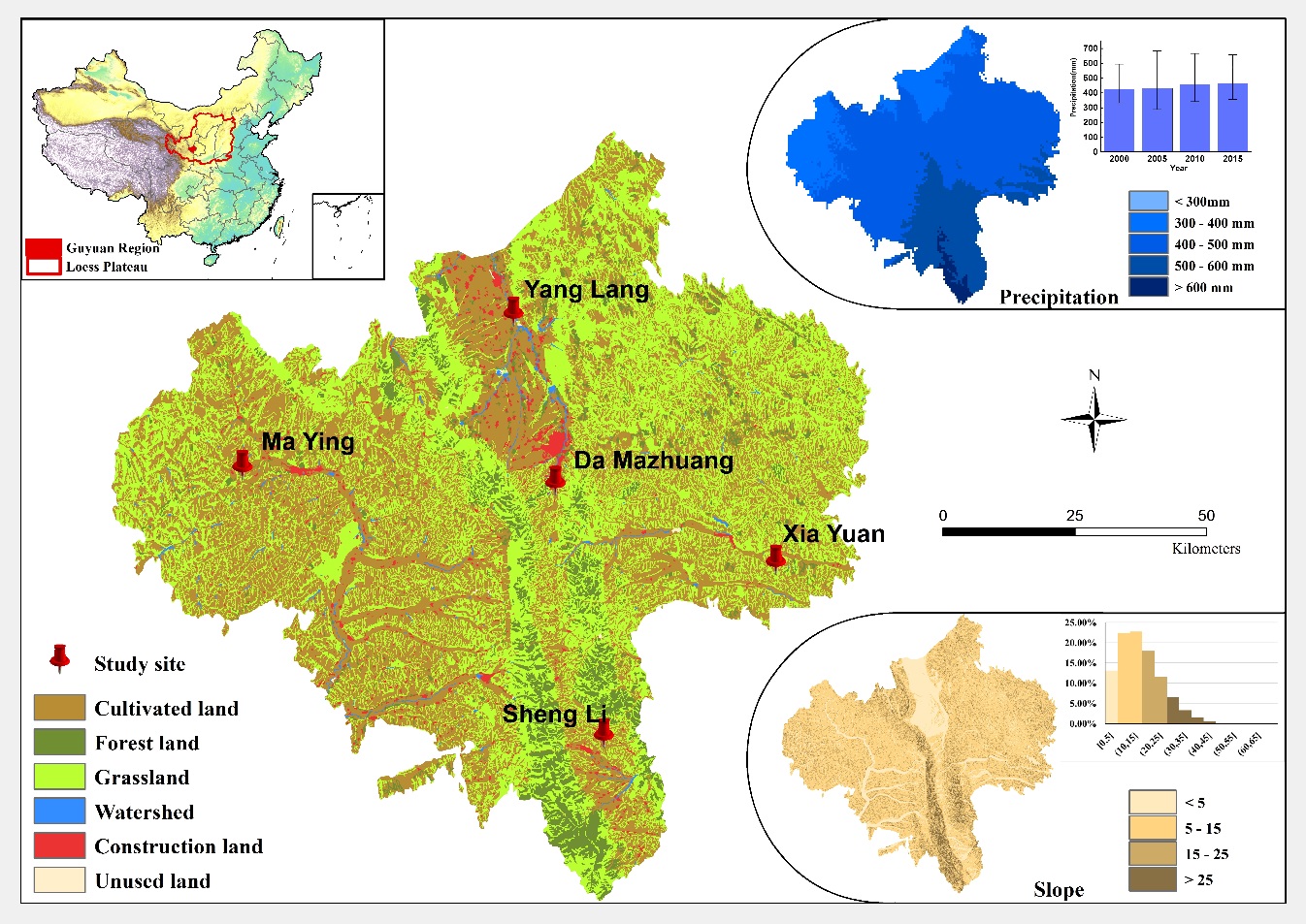
The major crops are winter wheat that are planted in rotation with summer maize and potatoes, which account for 48.0% of the total cultivated area. The agricultural population is 1.11 million, and these workers account for 74.4% of the total population. However, the disposable income of rural households is 7002.1 CNY, which was lower than the provincial average of 9119.0 CNY and the national average of 11 422.0 CNY in 2015 (Guyuan Bureau of Statistics, 2016b). The approximate conversion rate to USD in 2015 was approximately 6.4 CNY per USD (Xue & Zhen, 2018).
2.2 Description of Methodology Used
This study first employed the FoPIA to involve local government officers and experts. Through a series of workshops, we came to recognize LUFs and indicators in Guyuan City, identified relationships between LUFs and land-use types and assessed changes in LUFs over a period of 10 years under a scenario of a typical degree of development. Following this, we enlisted local farmers for our questionnaire survey to obtain the willingness and the drivers of the farmers’ land-use strategy. Based on the data derived from the questionnaire, we defined agent behaviour, and based on the LUF data obtained from the FoPIA, we initiated the contextual design of the ABM. Finally, we established the LUF change simulation model for Guyuan in combination with multi-level stakeholder data into the assessment procession, and based on this assessment data developed an ABM to simulate spatiotemporal LUF changes in Guyuan.
2.2.1 FoPIA for LUFs Assessment
The FoPIA was designed and adjusted based on Morris’ research (Morris et al., 2011). It was conducted in three phases: (1) Preparation phase, (2) Participatory evaluation, and (3) Analysis of the results. In the first phase, we initiated the preparation workshop with transdisciplinary experts in September 2015, enlisting 10 policymakers (Wang & Zhen, 2017), and we communicated regional land-use problems, associative driving factors as well as land management and policy issues. The drafting of local LUFs and associated assessment indicators was prepared during the next phase. In the participatory evaluation phase, the second workshop was held in May 2017, enlisting 5 policymakers and 5 researchers. Data derived from this workshop comprised of 4 separate parts, namely, defining and weighing the LUFs and associative indicators (with scores from 0 to 5 representing no importance to extremely important), determining future scenario assessments (with impact scores from -3 to 3 representing the most negative impacts to most positive impacts), recognizing relationships between LUFs and land-use types (with a contribution rate from 0 to 100) and discussing land-use strategies. In the final analysis of the results phase, the result was discussed and shared with local experts and researchers and a subsequently constructive recommendation was provided. Detailed processes related to FoPIA can be found in Supplementary Materials and a study by Xue and Zhen (Xue & Zhen, 2018).
2.2.2 Questionnaire to Determine Agent Behaviour
The household questionnaire was designed in three parts: The first part was concerned with basic family data including gender, age as well as the primary occupation and level of education of household members. The second part was concerned with their attitude to land-use issues, namely, whether they had abandoned agricultural land and the reason that they did so (if applicable). The last part was concerned with the status of land abandonment and the experience with land management measures, such as rural land transfer programs, which have been recommended in FoPIA by experts. Sample households were randomly chosen in each village, and the final sample size (i.e., the number of households) was based on suggestions from village managers to ensure reliability and representativeness. Between May 2 and 9, 2017, we conducted the questionnaire survey in each village through a face to face interview, and 202 valid questionnaires were collected in total.
2.2.3 Agent-based Model for Spatiotemporal LUF Changes
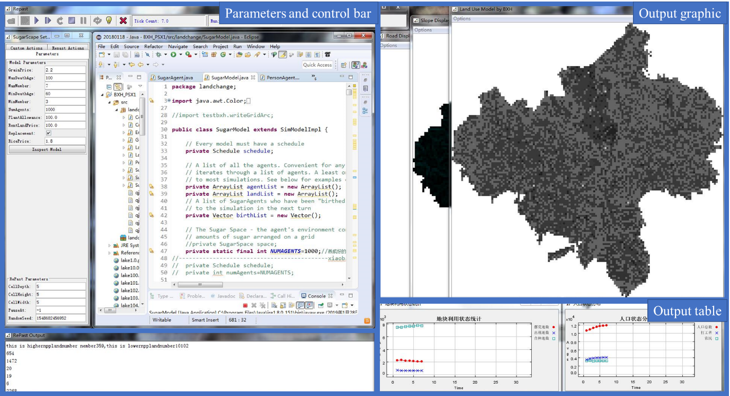
The model was based on Bai’s model (Bai et al., 2015), designed to simulate farmland changes. Our model is composed of four sub-models using four types of agents. The sub-models include an individual status transfer sub-model, a household classification sub-model, a spatial environment distribution sub-model and a household farmland land-use decision sub-model. Agents include individual agent, household agent, household group agent and the government agent. Figure 2 shows the interface of the ABM, developed using the Java language and the RePast simulation platform.
In this model, individual agents represent local residents, with basic characteristics including age and occupation. During model runtime, the individual status transfer sub-model was used to change each individual agent, and the structure of household agents, which consists of individuals, will also change. In the household classification sub-model, households are classified into subsidy-dependent, pure-farming, part-farming, non-farming and pure-outworking groups. Each group has different land-use strategies. Both characteristics and strategies were obtained from the questionnaire. The spatial environment distribution sub-model was designed to describe farmland quality and land abandonment or the transfer of land-use right, which rely on farmland quality. The household farmland land-use decision sub-model is the last sub-model to reflect the final condition of the land-use status and the coordinate distribution of LUFs.
We attempted to conduct the LUF simulations under the context of typical development practices, and we hypothesized that land-use efficiency and the abandonment of agricultural land would continue to follow current trends into the future. The spatial data resolution of the model was 1 km2. The meteorological data as well as land-cover and land-change data were provided by the Data Center for Resources and Environmental Sciences, Chinese Academy of Sciences (http://www.resdc.cn/). The simulation years investigated were from 2015 to 2025.
3. Results and Discussion
3.1 LUFs Weights
LUFs were defined and separated into three different dimensions, including the economic dimension, the social dimension and the environmental dimension, comprising of three LUFs and indicators in each dimension (Table 1). Detailed information on each LUF and indicator can be found in Supplementary Materials. The weights of LUFs, which reflect food security (SOC3; 4.50) and land-based production (ECO3; 4.33), remain the most fundamental issues for Guyuan, and farmers in this region are beginning to recognize the importance of the ecological environment. The high weights of ENV1 (the abiotic resource provision; 4.17) and ENV2 (the biotic resource provision; 4.00) reflect the effectiveness of the promotion and protection initiatives that have been conducted in the past several years (Xue & Zhen, 2018).
| Dimensions | Land Use Functions (LUFs) | Weights | |
| Economic | ECO1 | Residential or non-land-based activities | 3.50 |
| ECO2 | Infrastructure | 3.67 | |
| ECO3 | Land-based production | 4.33 | |
| Social | SOC1 | Provision of work | 2.50 |
| SOC2 | Quality of life | 3.17 | |
| SOC3 | Food security | 4.50 | |
| Environmental | ENV1 | Provision of abiotic resources | 4.17 |
| ENV2 | Provision of biotic resources | 4.00 | |
| ENV3 | Maintenance of ecosystem processes | 3.83 |
3.1 Matrix of LUFs and Land-use Types
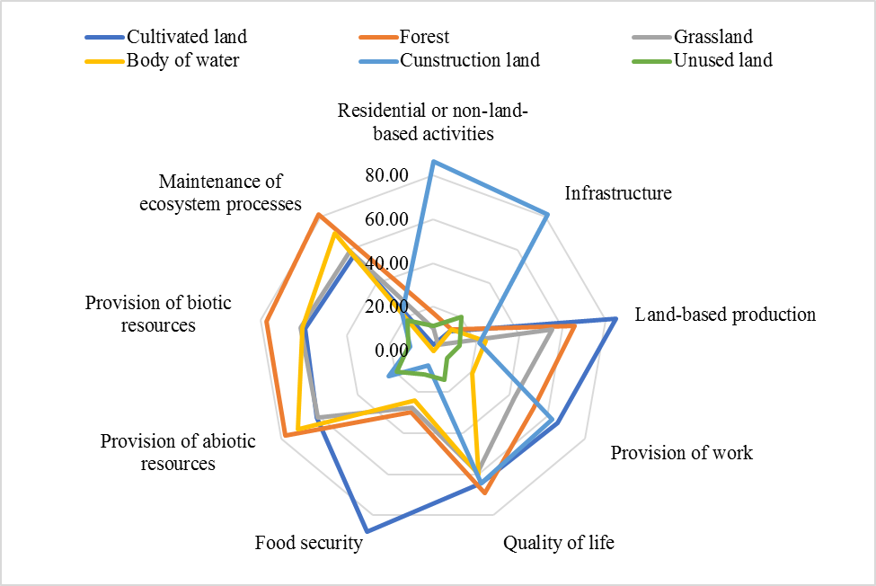
The results from the contribution matrix (Figure 3) show that cultivated land in Guyuan has the greatest contribution to food security (87.86; the contribution table can be found in Supplementary Materials), land-based production (84.71) and provision of work (65.71) functions. Forests were predominately good in LUFs in the environmental dimension, including the provision of abiotic resources (77.86), the provision of biotic resources and the maintenance of ecosystem processes (81.43), and they also have an outstanding influence on the quality of life function (69.29). In addition, construction land has a significant and uniquely important contribution to local residential or non-land-based activities and infrastructure (86.43), which benefits from its manufacturing features. Unused land offers little contribution to all LUFs, with an average contribution rate of 13.95.
3.2 Assessment Results of LUF Changes Over 10 Years
In summary, LUFs will have a slight improvement in 2025 according to the LUFs map in Figure 4. The most significant improvement will be in central Guyuan, where the primary land-use type is construction land. One reason for this is the expansion of the construction area and its contribution to the local economy. Another reason is that with urban and factory development, more work will be available for young people, which also plays a key role in social LUFs (SOC2: 1.71) according to FoPIA experts. Another important improvement is in the south section of the city, where the primary land-use type is forest. Since 2000, the sloping land conversion program (SLCP) has increased regional forest cover from 35% to 73% and has increased regional grassland cover from 12.8% to 22.2%, for a total increase of 3.11 × 10⁵ ha throughout the whole Guyuan City region. Trees and grass planted throughout the duration of this program will gradually mature and enhance the provision of biotic resources and the maintenance of ecosystem processes of LUFs [62]; thus, these enhancements will obviously improve the LUFs in the south section of the city.
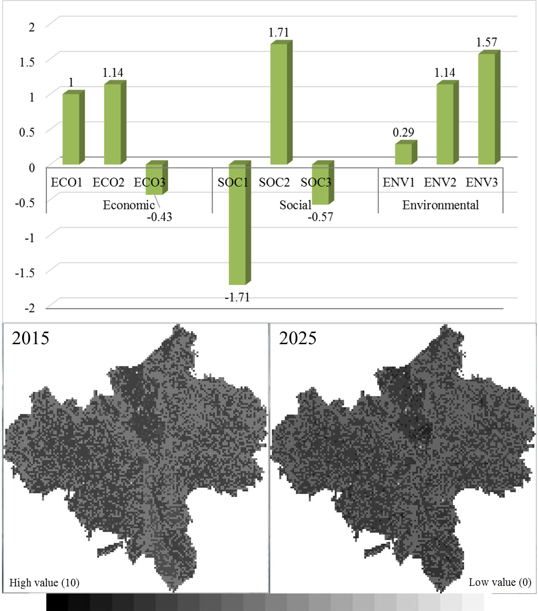
In the northeast and western sections of the city, where the primary land-use type is cultivated land, areas with low LUF values even expended. The reason for this is that if Guyuan develops as expected, the low benefits and high costs for farmers on poor-quality land will strongly motivate less agricultural work, and some households will effectively choose to abandon their land. With less stress on agricultural work and an increase in land abandonment, the importance of the provision of the work function would weaken (SOC1; -1.71) and food security (SOC3; -0.57) would subsequently be threatened. Moreover, the ability of abandoned agricultural land to provide land-based production will also suffer (ECO3; -0.43). However, land abandonment will also permit natural ecosystem recovery, which will promote the maintenance of LUF ecosystem processes (Sulieman, 2013; Zhang, Liu, Xue, & Wang, 2015) in combination with the SCLP (ENV3; 1.57).
3.3 Challenges for Stakeholder Involvement in Model Design
The model designed for this study is a type of artificial-social model, which was constructed based on mechanisms and running rules in accordance with local facts. Individual agent in this model is the basic unit to reflect the interaction with farmland through agent behaviours; thus, empirical characterizations and parameterizations are necessary. However, it is a major challenge to refine and assess differential behaviour through empirical observation (Filatova, Verburg, Parker, & Stannard, 2013). Some studies only used census data to simplify their models (Gaube & Remesch, 2013); however, the practical and social meaning of such models are lost in terms of behavioural description. In our model, we combined the FoPIA and a questionnaire to obtain both microscopical contextual data from experts and government officer workshops and microscopic empirical characterization data from individuals during face to face interviews. Although this model cannot effectively simulate all factors related to the human-environmental system, being concerned with key land-use behaviour and issues, rules of agents and mechanisms that impact agents under different land-use decisions provide significant practical data. Therefore, our model can support policymaking processes in complex social-ecological systems.
4. Conclusions
First, food security and land-based production are the most fundamental issues for Guyuan, and local farmers are beginning to recognize the importance of the surrounding environment. Cultivated land dominates LUFs in the social dimension, and forests contributed most to LUFs in the environmental dimension. Second, we built an agent-based model for LUFs based on multi-level stakeholder methods. Simulations from this model showed a remarkable change in central Guyuan owing to the expansion of the construction area and its contribution to local economic and work provisions. On the other hand, cultivated land area, primarily in the east and west of Guyuan, showed an overall decrease owing to the trend in agricultural land abandonment. Third, our model can directly reveal potential land-use issues, which helps policymakers to design land management measures for regions that have unique and complex land-use conditions.
In Guyuan, land abandonment is a serious issue. Therefore, promoting the attraction to cultivate land is urgently needed in this region to improve cultivated land-use efficiency. Considering the positive effects that SLCP has had on Guyuan City, it would be feasible to promote this program into a border area, and the development of a forest economy is also an alternative choice for efficient rural land-use practices.
Results from this study have certain limitations. On the one hand, given that the simulation resolution of this model is 1 km2, small plots in Guyuan were not considered. On the other hand, located in a hilly and gully loess region, land-use plots, particularly cultivated plots, are historically small and discrete in this region. During the next phase of development, we intend to employ a higher spatial resolution in our model to further observe and analyze regional land-use issues and potential land management methods. ABMs on a village scale or at a level that can distinguish between land forms should be constructed to make good use of empirical stakeholder data and obtain more targeted policy recommendations.
Acknowledgement
We would like to thank the Asia-Pacific Network for Global Change Research (APN) for its financial support to this valuable research. We are also grateful to the Institute of Geographic Sciences and Natural Resources Research, Chinese Academy of Sciences, for its support during the implementation of the study. We would also like to acknowledge the help we received from local government bodies, institutes, village leaders and households that aided us in accomplishing our research objectives and helped us achieve a thorough understanding of local conditions.
Supplementary Material
References
- Bai, X., Yan, H., Pan, L., & Huang, H. (2015). Multi-Agent Modeling and Simulation of Farmland Use Change in a Farming–Pastoral Zone: A Case Study of Qianjingou Town in Inner Mongolia, China. Sustainability, 7(11), 14802-14833.
- FAO. (2011). The state of the world’s land and water resources for food and agriculture (SOLAW) – Managing systems at risk. Food and Agriculture Organization of the United Nations, Rome and Earthscan, London.
- Filatova, T., Verburg, P. H., Parker, D. C., & Stannard, C. A. (2013). Spatial agent-based models for socio-ecological systems: Challenges and prospects. Environmental modelling & software, 45, 1-7.
- Gaube, V., & Remesch, A. (2013). Impact of urban planning on household’s residential decisions: An agent-based simulation model for Vienna. Environmental Modelling & Software, 45, 92-103.
- Guyuan Bureau of Statistics. (2016a). 2015 Handbook of socio-economic development statistics in Guyuan. Guyuan: Guyuan Bureau of Statistics.
- Guyuan Bureau of Statistics. (2016b). 2015 Statistical communiqué for national economic and social development in Guyuan. Guyuan: Guyuan Bureau of Statistics.
- Kappas, M., Groß, U., & Kelleher, D. (2012). Global Health: A Challenge for Interdisciplinary Research. Universitätsverlag Göttingen.
- König, H. J. (2013). Operationalising sustainability impact assessment of land use scenarios in developing countries: a stakeholder-based approach with case studies in China, India, Indonesia, Kenya, and Tunisia.
- König, H. J., Schuler, J., Suarma, U., McNeill, D., Imbernon, J., Damayanti, F., … & Morris, J. (2010). Assessing the impact of land use policy on urban-rural sustainability using the FoPIA approach in Yogyakarta, Indonesia. Sustainability, 2(7), 1991-2009.
- Liniger, H., Mekdaschi, R., Moll, P., & Zander, U. (2017). Making sense of research for sustainable land management. Centre for Development and Environment (CDE), University of Bern and Helmholtz-Centre for Environmental Research GmbH–UFZ.
- Millennium Ecosystem Assessment (2005). Ecosystems and human well-being (Vol. 5). Washington, DC: Island press.
- Morris, J. B., Tassone, V. C., de Groot, R. S., Camilleri, M., & Moncada, S. (2011). A framework for participatory impact assessment: Involving stakeholders in European policy making, a case study of land use change in Malta. Ecology and Society, 16(1).
- National Research Council. (2014). Advancing land change modeling: opportunities and research requirements. National Academies Press.
- Orr, B. J., Cowie, A. L., Castillo Sanchez, V. M., Chasek, P., Crossman, N. D., Erlewein, A., … & Tengberg, A. E. (2017). Scientific conceptual framework for land degradation neutrality. In A report of the science-policy interface. United Nations Convention to Combat Desertification (UNCCD), Bonn, Germany.
- Peng, J., Liu, Z., Liu, Y., Hu, X., & Wang, A. (2015). Multifunctionality assessment of urban agriculture in Beijing City, China. Science of the Total Environment, 537, 343-351.
- Pérez-Soba, M., Petit, S., Jones, L., Bertrand, N., Briquel, V., Omodei-Zorini, L., … & Wascher, D. (2008). Land use functions—a multifunctionality approach to assess the impact of land use changes on land use sustainability. In Sustainability impact assessment of land use changes (pp. 375-404). Springer, Berlin, Heidelberg.
- Sulieman, H. M. (2013). Natural regeneration potential of abandoned agricultural land in the southern Gadarif Region, Sudan: implications for conservation. African journal of ecology, 52(2), 217-227.
- United Nations. (2017). The Sustainable Development Goals report 2017. New York, USA: United Nations
- Valbuena, D., Verburg, P. H., Veldkamp, A., Bregt, A. K., & Ligtenberg, A. (2010). Effects of farmers’ decisions on the landscape structure of a Dutch rural region: An agent-based approach. Landscape and Urban Planning, 97(2), 98-110.
- Wang, C., & Zhen, L. (2017). A comparative assessment of land use functions based on perceptions of policy makers and local farmers in Guyuan, western China. Journal of resources and ecology, 8(3), 232-242.
- Wei, Y. J. (2010). Multi-functionality of Land Use in Jinghe Region of Northwestern China. University of Chinese academy of sciences: Beijing, China.
- Wiggering, H., Müller, K., Werner, A., & Helming, K. (2003). The concept of multifunctionality in sustainable land development. In Sustainable development of multifunctional landscapes (pp. 3-18). Springer, Berlin, Heidelberg.
- Xie, G., Zhen, L., Zhang, C., Deng, X., Koenig, H. J., Tscherning K., & Helming, K. (2010). Assessing the Multifunctionalities of Land use in China. Journal of Resources and Ecology, 1(4), 311-319.
- Xue, Z., & Zhen, L. (2018). Impact of rural land transfer on land use functions in western China’s Guyuan based on a multi-level stakeholder assessment framework. Sustainability, 10(5), 1376.
- Zhang, C., Liu, G., Xue, S., & Wang, G. (2015). Changes in rhizospheric microbial community structure and function during the natural recovery of abandoned cropland on the Loess Plateau, China. Ecological Engineering, 75, 161-171.
- Zhen, L., Cao, S. Y., Wei, Y. J., Xie, G., Fen, L. I., & Yang, L. (2009). Land use functions: Conceptual framework and application for China. Resources Science, 31(4), 544-551.